Zuluk & Nathang Valley: Silk Route Road Trip Guide (real talk, real roads) #
I’ve wanted to do the Silk Route since, like, forever. Those zig‑zags above Zuluk kept popping up on my Insta explore and you know how the brain works — once it hooks onto a road, it just won’t let go. So yeah, I finally did it. A proper East Sikkim road trip with chai-stops, army checkposts, fog that eats your car whole, and sunrises that slap you awake in the best way. Not gonna lie, it wasn’t all smooth… my phone network ghosted me, I slightly under-packed woolens (rookie move), and I ate so much thukpa that I basically turned into soup. But I came back with this weird mix of peace and adrenaline in my bones. If you’re planning Zuluk, Nathang, Kupup, Baba Mandir — everything along the old Silk Route — here’s exactly what I did, what worked, what I’d do different, and the stuff no one tells you until you’re already on that soggy hairpin.
Why the Silk Route still feels mad special#
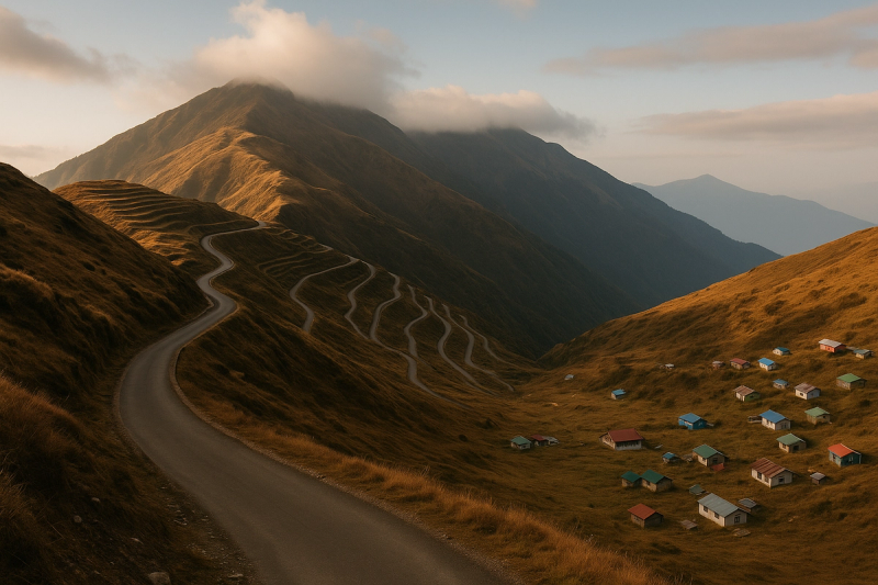
So, um, short story? It still feels raw. Not in a rough way, but in that unpolished, honest way. Zuluk sits around 9,000+ ft and it’s really just a mountain village with homestays that smell like wood smoke and Maggi and sometimes yak meat if you’re lucky. Nathang Valley (they also spell it Gnathang, don’t stress) is up at roughly 13,000+ ft — open, bleak, golden in autumn, full white in winter. The area is crisscrossed with Indian Army posts and old trade paths to Tibet, and you feel that border energy. But the real reason it hits is the drive — those 32 or so loops above Zuluk to Thambi View Point. It’s not just another road; it’s the kind of road that makes you talk to your car. Or to God. Or both. Photos don’t do justice. Never did.
Permits, current updates, and the slightly confusing bits#
Okay, the confusing part first, so you don’t get stuck at a gate. Zuluk, Nathang, Kupup etc are in a protected zone of East Sikkim. Indian nationals need a Protected Area Permit (PAP) to enter beyond Rongli checkpost. Any local tour operator or your homestay can arrange it — carry a valid government photo ID (passport or voter ID is safest), a couple of passport photos, and a soft copy on your phone. Aadhaar sometimes works, sometimes the officer wants voter ID — don’t argue, just carry both if you can. Foreign nationals usually aren’t allowed on this stretch beyond certain points and should check Sikkim Tourism for what’s permitted. Also Nathu La is a separate permit altogether and is only open on specific days, usually not Mondays and Tuesdays. As of early 2025, the drill remains the same: permits through registered agents, checkposts at Rongli and further up, and occasional last‑minute closures because of weather or army movement. Don’t bring a drone. Seriously, don’t.
How to reach and which route actually makes sense#
Most folks do NJP/Bagdogra to Rongli side and then climb. We started from Siliguri, took NH10 past Sevok, then up to Rhenock and Rongli where your permits get checked. From there: Padamchen (nice for first night acclimatisation), then Zuluk, Thambi View Point, Lungthung, Nathang Valley, Kupup Lake (Elephant Lake), Old Baba Mandir, and if the route is open, loop towards Tsomgo and Gangtok. If not, you backtrack a bit. Public transport is patchy beyond Rongli, so a reserved cab is the stress-free move. Prices swing by season but expect around 5k–8.5k per day for a Sumo/Bolero with driver, fuel included, depending on how many days and how far you go. Self-drive? I mean you can, but the hairpins are tight, winter needs chains sometimes, and visibility goes from fine to ‘where’s the road bro’ in five minutes. Get a local driver unless you really love stress.
That famous zig‑zag and the pre-dawn panic#
We left Zuluk in pitch dark for sunrise at Thambi View Point. I don’t know what possessed me — I was in three layers but still shivering, the car windshield kept misting up, and my brain was like… chai? But when the first light hit those layers of loops and the Khangchendzonga massif started showing off, I forgot my toes. Someone near us had that tiny Bluetooth speaker playing an old Kishore track and the whole place went silent except that. By the time the sun came up proper, the mountains looked painted. If the weather’s clear, this is the moment. If it’s foggy, accept it. The Silk Route is moody and she doesn’t care for your plans. On the way up, keep an eye for mountain pheasants, and on the way to Lungthung there are a couple of tiny tea stalls run by families — buy something, it genuinely helps.
Best season to go (and when not to go, unless you like chaos)#
Two sweet windows: April–May when rhododendrons pop and the valleys are all kinds of pink‑red, and October–November for crispy skies and the big mountain views. Winter from late December to February is straight up snow drama — could be magical or could be roadblock city. If you’re chasing snow, yes, but be flexible, keep buffer days, and always check with your homestay guy a day before moving. Monsoon, June–September, is landslide prone and visibility is messy. It’s lush, sure, and the waterfalls are in beast mode, but you gotta be patient. Night temps can crash even in shoulder seasons, and Nathang can easily dip below zero with wind. Layer up. Thermals, fleece, a proper jacket, beanie, gloves, good socks. Don’t do that ‘I’m strong’ thing — the cold doesn’t care, and neither does the wind that slices your ears at 13k ft.
Where to stay: homestays over hotels, always#
There aren’t big hotels up here, and that’s the charm. In Zuluk and Padamchen you’ll find clean homestays, mostly wooden rooms, bucket hot water or sometimes geysers powered by solar. In Nathang Valley it’s simpler, because of altitude and logistics — rooms are basic but cozy, with heavy quilts and hot water buckets. Pricing depends wildly on season but think around 1500–3000 per person per night including dinner and breakfast. Ask what’s included — many homestays feed you like family: rice, dal, veg curry, eggs, achar, sometimes pork or chicken if available. Electricity can be flaky. They’ll run generators in the evening and cut off later. It’s okay, you didn’t go there for Netflix anyway. Pick lower altitude (Padamchen or Zuluk) for your first night, then Nathang next day. That slow climb… your head will thank you.
Food and those tiny kitchens that save your soul#
It’s mountain food, so expect hot carbs and simple flavours that feel like a hug. I lived on veg thukpa, momos (pork if you eat, otherwise cabbage paneer is common), wai‑wai fry, omelette‑bread with black tea so strong it could fix heartbreak. Try churpee (that chewy yak/cow milk cheese) and gundruk if they have it. Some homestays do phagshapa (pork with radish, tangy) or local noodles like gyathuk. If you see Tongba or Chaang (millet beer) on a cold evening, it hits nice — but go slow, high altitude and alcohol are not best friends. Carry snacks from Rongli or Rhenock — nuts, chocolate, glucose biscuits — because after Lungthung, shops are basically wind. And btw, please don’t push for fancy café orders; they cook what’s possible at that altitude and supply chain. Appreciate it. The best meals were not photogenic, they were warm.
Safety, acclimatisation, and listen to your body stuff#
Nathang Valley is high. Like, properly high. Some people feel nothing, some get headaches, nausea, or can’t sleep. The trick is boring but works: go up slow, hydrate, skip alcohol on day one, and keep moving gently instead of flopping straight into bed. If you’ve got a history of altitude issues, talk to your doctor before the trip — some carry Diamox, some don’t; I’m not your doc. If you wake up with a bad headache and heavy breathing at Nathang, tell your host immediately — they often have oxygen cans or a way to descend to Zuluk/Padamchen quickly. Roads are narrow, with rolling stones and surprise ice patches in winter. Seatbelts, always. If you feel car‑sick, ask your driver to go easy and sit in front. And please, don’t sprint around for selfies at Thambi View Point. You’ll just end up wheezing and pretending you’re fine.
- Start your day early, like 6 am early. Weather is kinder in the mornings, views are clearer, and you’ll cross checkposts before any traffic piles up.
Hidden corners and tiny detours that made it special#
The big names are great — Thambi, Kupup, Old Baba Mandir — but the trip is actually made of the in‑betweens. At Lungthung, a grandpa running a tea stall told me his winter snow stories while frying me an egg on this ancient pan, and honestly that memory sits louder than a lot of ‘sights’. If the road is open, ask your driver to pause at Tukla Valley for the war memorials — quiet, windy, beautiful. Kupup Lake (Elephant Lake) looks unreal on a clear day, but don’t chase the edge for photos; the slope is trickier than it looks. The Yak Golf Course is out there too, and it’s kinda wild to see a golf board at that altitude, though visiting rules keep changing and often tourists aren’t allowed in — respect the signs. And if you’re coming via Aritar side, Lampokhari Lake has a little local festival around April with archery and stalls — not flashy, but pure vibe.
- Thambi View Point sunrise is a must, but also stop at the tiny bend viewpoints the driver knows. Some frames are better than the popular deck.
- Old Baba Mandir feels calmer than the new one near Tsomgo. Spend a minute, not just a photo.
Cash, networks, fuel and the few boring things that actually matter#
Do this prep and you’ll thank yourself later. ATMs get sparse after Rongli and may just not work. Carry cash. Homestays mostly prefer cash or GPay when the network gods are smiling. Fuel up at Rhenock or Rongli — after that, nada. Networks: Jio and BSNL show up more often than Airtel in my experience, but it’s patchy. WhatsApp texts might go, calls are moody, data is ‘try your luck’. Download offline maps before you leave. Keep your physical IDs handy for checkposts, and your permits in an easy folder. There’s a strict ban on drones and often a no‑photo rule near certain army areas — if a board says no photos, don’t argue. Also, Sikkim is serious about plastic; carry a bottle, refill whenever possible. Powerbanks, headlamp, and sunscreen — yes sunscreen, high altitude sun burns through clouds like it’s personal.
Costs and what I actually spent (roughly, don’t come for me)#
Ballpark numbers so you can plan. From Siliguri/NJP side, a private cab for the Silk Route circuit worked out around 5–8k a day for the vehicle, depends on the route, season, negotiation, and whether you loop to Gangtok. Homestays averaged 1800–2500 per person per night including two meals, chai, and evening snacks sometimes. Extra lunch at roadside dhabas was 150–300 for a plate of rice, dal, sabji, egg curry, or Maggi/Momos. Permits are usually handled by the operator or homestay for a small fee per person — some include it in package cost. If you add Nathu La (when open and permit granted), it’s an extra cost, applied via registered agent from Gangtok. Buying winter gear up there will hurt your wallet; better to bring your own. I spent more on spontaneous tea and snacks than I expected — small places add up, but it also directly supports locals, which felt right.
Culture, locals, and being a decent guest#
East Sikkim has this calm, self‑contained rhythm. Many families have someone serving in the Army, or relatives in Gangtok/Siliguri, and life ticks with the weather and the road. People are polite and so used to tourists coming in waves and then disappearing when the snow hits. Learn a few basics — a lil ‘namaste’, ‘julley’ sometimes gets used further west but folks get the sentiment, and a smile works everywhere. Don’t blast music at viewpoints, don’t litter, don’t go stomping into private fields for that ‘authentic’ shot. Ask before you photograph people. If you’re vegetarian, say clearly. If you’re not, still be flexible — supplies are limited and menus run out. Bonfires might be restricted depending on season and forest rules, so don’t demand one. And if someone asks you to move because of army convoy or weather, just move. You’ll still get your sunset another day.
Btw, here’s the rough route that worked for us#
Day 1: NJP/Bagdogra to Padamchen via Rongli — easy pace, manage permits, early dinner, sleep. Day 2: Padamchen to Zuluk, pre‑dawn to Thambi for sunrise, slow crawl up to Lungthung, reach Nathang Valley by afternoon, hot lunch, chill and breathe slow. Day 3: Nathang to Kupup Lake, Old Baba Mandir, and if the road is open plus permits sorted, swing towards Tsomgo and then down to Gangtok. If closed, either overnight again at Zuluk or Padamchen, depending on energy and weather. On paper it’s simple. On the ground, the weather decides. Keep buffer. If you’ve got an extra day, add Aritar at the start — Mankhim viewpoint over Lampokhari at dawn is a soft, gentle intro before the big loops slap you with majesty. Oh and carry motion sickness meds if you’re sensitive; those curves don’t negotiate.
What I’d do differently next time (and you probably should too)#
Pack one more warm layer than you think you need. Carry a thermos so your chai stays hot while you gawk at mountains. Start earlier on day two — sunrise lineups at Thambi can get mildly crowded on good days, and the best spots are actually the smaller bends a bit before it. If you’re into birds, add a day around Padamchen/Zuluk forest stretch — early hours you might spot monal or blood pheasant if luck loves you. Get a local SIM if you don’t have Jio or BSNL, just for emergency calls. And maybe spend two nights in Zuluk instead of rushing to Nathang — one to acclimatise and one for slow walks. I also wish I’d carried small gifts for homestay kids — notebooks, pencils. Cash tips are fine too, but those small, thoughtful things go a long way. Also, hydrate way more. I kept forgetting because it was cold, and that’s dumb.
A few no‑nonsense rules that saved my trip#
- Weather and road checks every evening with your driver and homestay. If BRO or local police says the pass is dodgy tomorrow, don’t fight it. Shift your plan.
Parting feels — the Silk Route does something to you#
I left with mud on my shoes and my cheeks cracked from the wind and grinning anyway. Zuluk’s wooden staircases creaked me awake at dawn, Nathang’s wind was so loud it felt like the valley was talking, and Kupup flashed blue like someone had toggled saturation to 200 for a second. The road teaches patience — sometimes all you can do is sip tea and wait for the fog to blink. I totally get why folks keep returning. It’s not just ‘scenic’. It’s the way the place lets you be a little small and a little brave on the same day. If you’re planning it, do it slow, do it kind, and let go of that perfect‑itinerary obsession. The Silk Route has its own itinerary for you anyway. For more such no‑nonsense travel stories and proper planning guides, I keep browsing AllBlogs.in — lots of India-first, practical stuff there that actually helps on the road.


