Why a Lofoten Road Trip Belongs on Your Bucket List
#Norway's Lofoten Islands look like a mountain range that drowned in the Arctic Ocean. 
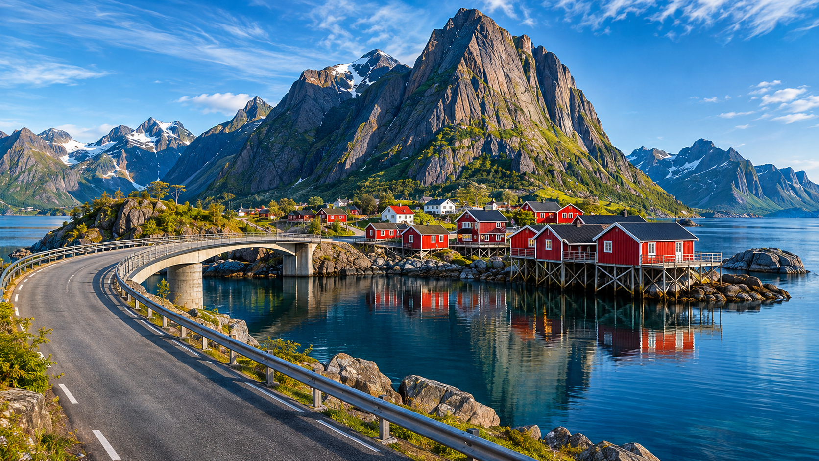
Located 100 miles north of the Arctic Circle, this jagged wall of prehistoric granite rises straight out of turquoise fjords, connected by arching cantilever bridges, undersea tunnels, and a single ribbon of asphalt called the E10 highway. Along the water sit clusters of bright red wooden fisherman cabins called rorbuer, set against sheer mountain cliffs that look like something out of a fantasy novel.
Because public buses run infrequently through these remote fishing hamlets, renting a car is the only realistic way to explore Lofoten. 
With four days on the road, you can drive the entire length of the archipelago from Svolvær down to the historic village of Å, climb the world-famous Sherpa staircase of Reinebringen, walk on white Arctic beaches that look like the Caribbean, and watch the midnight sun glow across the sea at two in the morning.
Here is a complete, realistic 4-day road trip itinerary covering driving rules, airport choices, hiking conditions, and how to avoid spending a fortune in one of the most expensive regions on earth.
Which Airport to Choose: Evenes vs. Leknes vs. Svolvær
#The first logistical hurdle every traveler faces when planning a trip to Lofoten is figuring out how to get there.
The islands have two small regional airports (Leknes and Svolvær) and one large mainland airport (Harstad/Narvik Evenes). Where you land completely changes your budget and driving time.
Option 1: Harstad/Narvik Airport Evenes (EVE) – Best for Budget
#Evenes is located on the Norwegian mainland, roughly 170 kilometers (105 miles) east of Svolvær.
- Flight Costs: Major airlines like SAS and Norwegian fly large jets directly into Evenes from Oslo several times a day. Flights are significantly cheaper than flying on regional prop planes.
- Car Rentals: Evenes has all major rental car counters with large fleets of vehicles, which keeps rental rates 30 to 40 percent lower than on the islands.
- The Tradeoff: You must drive 2.5 hours along the E10 highway through mountain passes just to reach Svolvær, the gateway to Lofoten. If you arrive late in the evening, this can be an exhausting drive in the dark or fog.
Option 2: Leknes Airport (LKN) – Best for Convenience
#Leknes is a small regional airport located right in the geographic center of the Lofoten archipelago.
- Logistics: Widerøe operates small Dash-8 turboprop planes into Leknes from Bodø. When you step off the plane, you are already in the heart of the islands.
- Driving Time: You are only 15 minutes from Haukland Beach and 50 minutes from the dramatic southern fjords of Reine and Hamnøy. You waste zero time backtracking.
- The Tradeoff: Prop flights from Bodø are more expensive and luggage allowances are strictly enforced. Rental car fleets in Leknes are small and book out months in advance during summer.
Option 3: Svolvær Airport (SVJ)
#Located in the north, right outside Lofoten's largest town. It offers similar regional turboprop connections to Leknes, making it a great alternative if you plan to explore the northern fjords and Henningsvær on your first afternoon.
Our Recommendation: If you have four days and want to maximize every hour of sightseeing, fly into Leknes. If you are traveling as a family or watching every dollar, fly into Evenes and enjoy the scenic road trip across the mainland bridges.
Driving in Arctic Norway: E10 Highway and Single-Lane Bridges
#Driving in Lofoten is an absolute pleasure, but it requires patience and a specific set of road manners.
The entire archipelago is threaded by the E10 National Tourist Route, a 230-kilometer two-lane highway that hugs the coastline. While the road is fully paved and in fantastic condition, it is narrow, twisty, and surrounded by water on one side and sheer granite walls on the other.
The Blue "M" Sign (Møteplass)
#Many of the dramatic arching bridges connecting the smaller islands are only wide enough for a single vehicle. 
Whenever you approach a narrow section of road or a single-lane bridge, watch for blue square road signs stamped with a white letter "M". This stands for Møteplass (meeting place).
- An "M" indicates a small paved cutout where two cars can safely pass each other.
- If you see an oncoming car approaching a single-lane stretch and the "M" sign is on your right-hand side, you must pull into the cutout and stop to let the oncoming car pass.
- Never use an "M" cutout as a scenic photo parking spot. Blocking a passing bay on a narrow bridge will earn you angry honks from local delivery trucks and fishing trawlers.
Rent an All-Wheel Drive (AWD)
#Even in the summer months of July and August, Arctic weather changes in minutes. A sunny morning can turn into torrential rain, high winds, and dense coastal fog within thirty minutes.
Rent a modern vehicle with all-wheel drive and good ground clearance. Make sure your rental package includes full collision damage waiver (CDW), as flying gravel chips and narrow parking spots along rocky trailheads frequently scratch vehicle paint.
Day 1: Arriving in Svolvær and the Magic of Henningsvær
#Your road trip begins in Svolvær, the commercial and artistic capital of the archipelago.
Afternoon: Picking Up Your Car and Svolvær Harbor
#After collecting your rental car at the airport, drive into Svolvær. The town sits under the dramatic shadow of the Svolværgeita (the Svolvær Goat), a twin-pinnacled granite rock spire that towers 569 meters above the harbor.
Take an hour to stretch your legs around the harbor promenade. Svolvær is an active working fishing port where commercial boats unload fresh cod, halibut, and Arctic shrimp every afternoon. Stop at a local bakery and grab a fresh kanelbolle (warm Norwegian cinnamon cardamom bun) to fuel your afternoon drive.
Late Afternoon: Driving into Henningsvær
#From Svolvær, head south along the E10 for 25 minutes, then take the scenic coastal detour south toward Henningsvær. 
This short seven-kilometer drive crosses two dramatic single-lane humpback bridges that leap across turquoise ocean channels. The views from the top of these bridges are breathtaking—keep your eyes open for sea eagles soaring overhead.
Henningsvær is often called the "Venice of the North." It is a historic fishing village spread across several tiny islands surrounded by open ocean. 
Park your car in the designated visitor lot at the entrance of town (never drive into the tiny residential streets) and walk into the village center. The main canal is lined with weathered wooden fishing sheds, cozy specialty coffee roasters, and traditional wooden racks called hjell, where thousands of whole cod are hung to dry in the cool Arctic sea breeze.
Evening: The World-Famous Football Pitch
#Walk all the way to the southern tip of the island to visit one of the most photographed sports grounds on earth: the Henningsvær Stadion.
This football pitch is carved directly into a bare, flat slab of solid granite rock, surrounded on all four sides by the crashing Atlantic Ocean and wooden cod drying racks. There are no stadium grandstands—only jagged rocks and the sea. Standing in the middle of this emerald-green artificial turf pitch listening to the waves crash against the rock is an surreal Arctic experience.
Head back into town for dinner at a local harbor cafe. Order a steaming bowl of traditional creamy Norwegian fish soup (fiskesuppe) loaded with fresh cod, salmon, carrots, and sweet ocean prawns, served with dense rye bread and salty butter.
Day 2: Arctic White Sand Beaches and Checking into a Red Rorbu
#Day two takes you through the most dramatic coastal landscapes in northern Europe.
Morning: Haukland Beach and the Old Coastal Road
#Pack your bags and drive southwest along the E10 toward the island of Vestvågøy. 
Turn off the main highway toward Haukland Beach. When you step onto the sand, you will swear your eyes are playing tricks on you: the beach features brilliant, powdery white sand and shimmering turquoise-green water that looks identical to a tropical beach in the Caribbean.
The only difference is the temperature: the water hovers around a brisk 11°C (52°F), and the sand is framed by massive, emerald-green granite mountains rising 400 meters directly out of the surf.
If the weather is clear, take the easy, flat coastal walking trail that wraps around the rocky headland from Haukland to neighboring Uttakleiv Beach. 
This three-kilometer old cart road was built before the mountain tunnel was blasted through the rock. It offers gentle, panoramic ocean walking with zero elevation gain. Uttakleiv is famous for its smooth, giant spherical boulders polished by thousands of years of heavy Atlantic surf, known locally as "dragon eggs."
Midday: The Frozen-in-Time Village of Nusfjord
#Drive back to the E10 and continue heading south across the Kåkern Bridge onto the island of Moskenesøya. 
Take the narrow, winding side road down into Nusfjord, one of the oldest and best-preserved historic fishing villages in Norway. Tucked deep inside a narrow, sheltered fjord gorge, Nusfjord feels like an open-air museum. 
Walk along the wooden docks built in the late 1800s. You can tour the historic cod liver oil factory, the old smithy, and the original general store (Landhandel), which still sells traditional sweets, warm coffee, and historic fishing gear in a room lined with dark wood paneling from 1907.
Afternoon: Checking into Hamnøy
#Continue south along the E10 until you cross the bridge into Hamnøy.
Hamnøy is the iconic postcard image of Norway that you have seen on magazine covers: a cluster of bright red wooden rorbuer cabins built on wooden stilts over the water, backed by the sheer, terrifyingly steep wall of Mount Festhelltinden.
Check into your traditional rorbu cabin. While these cabins were originally built in the 19th century to house impoverished fishermen during the brutal winter cod season, they have been beautifully restored into warm, luxury holiday cottages. 
Inside, you will find exposed spruce beams, modern heated tile bathrooms, a wood-burning stove, and a fully equipped kitchen. Best of all, your living room window looks straight out over the rushing water of the fjord.
Pour a cup of hot tea, sit out on your private wooden dock, and watch the fishing boats glide quietly past your porch.
Day 3: Conquering Reinebringen, Scenic Reine, and the Village of Å
#Day three is the physical highlight of the road trip: climbing the most famous viewpoint in Scandinavia.
Morning: Conquering the 1,560 Sherpa Steps of Reinebringen
#Reinebringen rises 448 vertical meters above the village of Reine. For decades, the trail to the summit was a treacherous, muddy goat track that caused dozens of mountain rescue operations every summer.
Between 2016 and 2021, the local municipality hired a team of expert Nepalese Sherpas to construct a permanent stone staircase up the mountain. 
Today, the trail consists of 1,560 massive granite stone steps that climb relentlessly up the steep mountainside. 
- The Strategy: Start early. Begin your climb by 8:00 AM before the tour vans arrive and before the midday sun beats down on the unshaded slope.
- The Climb: The staircase is wide, stable, and completely safe, but it is steep. You will climb 448 meters in less than two kilometers. Take a steady, slow pace and rest every 200 steps to let your heart rate settle.
- The Summit View: When you reach the top of the stone stairs at the mountain ridge, step out onto the narrow crest. The view that opens up below you is unforgettable: a 360-degree aerial panorama looking down onto the colorful island villages of Reine, Sakrisøy, and Hamnøy, connected by bridges across the deep sapphire-blue Reinefjord, backed by a jagged amphitheater of granite peaks.
Take your summit photos, sit on the grassy ridge to catch your breath, and descend slowly. The stone steps are hard on your knees—trekking poles are a massive help on the descent.
Afternoon: The Picturesque Village of Reine
#After descending Reinebringen, drive five minutes across the bridge into the village of Reine.
Reine sits in the center of the fjord amphitheater you were just looking down upon from the mountain ridge. Walk through the quiet streets and visit the local bakery for lunch. 
Order a warm fish burger (fiskekake) made with fresh Atlantic haddock, served on a soft bun with remoulade, followed by a cup of strong black coffee.
Late Afternoon: Driving to Å at the End of the Road
#From Reine, continue south on the E10 for ten more kilometers until the road literally ends.
Here sits the village of Å (pronounced "Oh"). It is the shortest town name in the world and marks the absolute southern terminus of the Norwegian road network. Beyond Å, there are only sheer ocean cliffs, seabird colonies, and the wild, open waters of the Norwegian Sea.
Å is a living, working fishing museum. Walk through the historic stockfish drying houses and visit the historic Bakeriet på Å, an authentic 1844 stone wood-fired bakery. During the summer, the baker fires up the massive 19th-century brick oven every morning, baking giant, fragrant cinnamon rolls (skillingsboller) using historic sourdough methods. 
Grab a warm roll straight from the oven and walk down to the rocky sea viewpoint at the very end of the trail to watch the waves break against the southern headland.
Day 4: Sakrisøy, the Ryten Hike, and Heading Home
#On your final day, take time for one more gentle hike and a legendary Arctic seafood lunch before catching your flight.
Morning: Yellow Cabins and Seafood at Sakrisøy
#Drive north from Hamnøy to the tiny island of Sakrisøy. 
Unlike Hamnøy where all the cabins are painted red (which historically indicated cheap cod-liver-oil-based paint), the historic cabins in Sakrisøy are painted a cheerful ochre yellow, indicating that the wealthy merchant families of the 1800s lived here.
Visit Anitas Sjømat, an iconic wooden fishmonger and gourmet market sitting on the dock. 
Order their famous smoked salmon and Atlantic shrimp sandwich on freshly baked bread. Sit on the outdoor deck overlooking the turquoise harbor and enjoy some of the freshest, sweetest seafood in Scandinavia.
Midday: Hiking Mount Ryten Overlooking Kvalvika Beach
#Before driving back toward the airport, treat yourself to one final hike: Mount Ryten.
While Reinebringen is a steep vertical staircase, Mount Ryten is a gentle, undulating three-hour mountain hike through open tundra and wooden bog boardwalks.
The trail begins near the hamlet of Fredvang. As you climb gently toward the 543-meter summit, the ridge suddenly drops sheer into the ocean, revealing an astonishing view of Kvalvika Beach nestled hundreds of meters below you. 
Kvalvika is a wild, inaccessible crescent of golden sand surrounded by vertical granite walls. From the rocky summit plateau of Ryten, you can stand safely on flat rock ledges that look straight down into the roaring surf below.
Evening: Return Drive to the Airport
#Hike back down to your car, change into comfortable travel clothes, and begin the scenic drive north along the E10 highway back to the airport. 
Drop off your rental car, check your bags, and board your flight, taking with you memories of the most dramatic coastal wilderness in Europe.
Midnight Sun vs. Northern Lights: Choosing Your Season
#Because Lofoten sits inside the Arctic Circle, the time of year you visit completely changes your entire travel experience.
The Midnight Sun (Late May to Mid-July)
#- The Experience: The sun never dips below the horizon for nearly two months. At midnight, the sky glows with a warm, golden, perpetual twilight that lasts for hours.
- Why It Is Great: You have 24 hours of daylight. If a popular trail like Reinebringen is crowded at 2:00 PM, you can simply go climb it at 11:30 PM under golden sunlight with not a single other hiker on the mountain.
- Packing Must: A high-quality contoured sleep mask is non-negotiable. Even with heavy wooden window shutters in your rorbu cabin, the bright Arctic sunlight will keep your body awake if your eyes are uncovered.
The Northern Lights Season (September to Early April)
#- The Experience: The polar nights return, bringing crisp, dark Arctic skies free of light pollution.
- Why It Is Great: Lofoten lies directly beneath the Auroral Oval. On clear nights between September and March, vibrant green and violet curtains of the Northern Lights (Aurora Borealis) dance directly over the jagged sea peaks and reflect in the calm waters of the fjords.
- The Tradeoff: Roads are covered in thick snow and sheet ice, requiring studded winter tires. Mountain trails like Reinebringen become dangerous avalanche zones accessible only to experienced mountaineers with crampons and ice axes.
Supermarket Survival: Budgeting in Norway
#Norway has a reputation for being extraordinarily expensive, and Lofoten is no exception. A casual dinner for two at a village restaurant with a glass of beer can easily run €120 to €150.
If you want to keep your trip affordable, follow the local secret: self-catering in your rorbu kitchen.
- Shop in Major Towns: Stock up on groceries the moment you land. Visit large budget supermarkets like Rema 1000 or Coop Extra in Svolvær or Leknes. Small village convenience stores in Hamnøy and Reine charge double for basic items.
- What to Buy: Buy Norwegian whole-grain bread, creamy local butter, eggs, tubes of smoked cod roe (kaviar), local cheeses, and fresh salmon fillets from the refrigerated case. Cooking your own breakfasts and dinners in your rorbu saves you 70 percent of your food budget while letting you dine directly on your private fjord deck.
With sturdy waterproof boots, an all-wheel drive car, and an open sense of adventure, a road trip through Lofoten will stay with you for the rest of your life.